Printable Version of Topic
Click here to view this topic in its original format
Mobile Gadget News :: Making Your Mobile Life Simpler _ Software Reviews _ Review :: Route 66 Mobile 7 Windows Mobile Smartphone
Posted by: smeg36 Apr 25 2007, 03:49 AM

Route 66 Mobile 7 Windows Mobile Smartphone
By http://www.66.com
MGN Rating - 
Rating Legend
1 star: Find something else; save your money
2 star: Below average; not recommended
3 star: Average; performs as advertised but not inspiring
4 star: Good; worth the money
5 star: Great; best of its kind on the market
Review by Smeg36
Review Date / April 25th, 2007
Intro
Do you find yourself lost frequently? Printing out maps from Google or Mapquest? We all know about GPS already. It's been gaining momentum over the last few years, and there are more and more options when it comes to hardware and software to choose from. Originally, if you owned a MS Smartphone your options were few. There have been more developers coming out with Smartphone applications that utilize GPS though. Route 66 is one such company. Their Mobile 7 software for the Windows Mobile Smartphone offers some unique advantages over other available options. Active voice guidance along with easy to view 3D maps, and a simple interface, make Route 66 Mobile 7 an option to seriously consider.
Installation
Installation of Route 66 Mobile 7 was a breeze. I inserted the DVD into my PC, and followed the easy-to-use directions. I had to put my miniSD in a card reader to transfer all the necessary files over. The only issue I encountered came when I inserted the miniSD into my Moto Q. The software is supposed to automatically begin the installation, but it didn't. No problem, I just browsed to the storage card with a file explorer and manually executed the .cab file. Once the .cab installed the program started up and began the process of activating. There are two options to activate the software, by internet or by SMS. I opted for internet, and was directed to obtain the serial number from the Route 66 website. After the activation was complete the program was ready to run. But wait, my bluetooth GPS receiver wasn't turned on!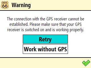
Performance
The first thing I noticed when I ran the program was the screen above. My GPS receiver wasn't turned on, so the program asked me if I wanted to retry searching for it, or continue using the software without the receiver. While you can use the software without the receiver, it really isn't much use. You can look up address' of the Points of Interest (POI), but can't navigate to them. So naturally I turned on my GPS receiver and began using the program with it.
When you first run the software it asks you which map you want to use. There are 9 different geographic map regions for Route 66, which can be found on http://www.66.com/route66/products.php?cid=US&sec=1&ssec=0&prodid=2885. I use the South as I'm in Florida. But I could also use the East or S-East regions as well. It is a little difficult to tell which region some of the states are in using the image on the website, and I couldn't find any list on the website that had which regions the states were in. My main issue with Route 66 is a result of the geographic region maps. There's no way to route between them. So if you're planning on going on a trip from California to Maine, you'd have to navigate to a point on the border of the two regions, then switch maps while making the trip. In this case you may want to check out http://www.mobilegadgetnews.com/index.php?showtopic=6832, which has major road maps available so you can make cross-country trips. Personally, I've only made 2 cross-country trips since GPS became available, so I'm not too worried about this issue.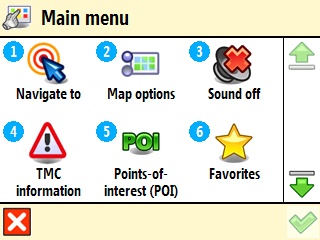
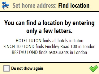
The main menu is accessed by pressing any direction on the d-pad. Once in there you can do many different things. The most common will be navigating to a location. Route 66 Mobile 7 offers a proprietary search engine that is supposed to make it easy to find locations. Instead of typing in the full address or business name, you only need to use part of it to find your destination. I found it to be somewhat difficult to use at first, until I figured out the best method. I enter the location address and zip code, and it will usually find exactly what I'm looking for. If I put in partial words or street address', or the city name instead of zip code, it can find hundreds of results or none at all. The most consistent method I found was the address and zip. You can also have it navigate you to an address of a contact, but I've found that to be hit or miss. It works sometimes, and doesn't others.

One of the most useful features, especially on landscape devices, is the ability to change the turn arrows from horizontal to vertical. On landscape devices, like the Q, I found other GPS programs difficult to use. Mapopolis, for example, would take up half the screen with the navigation bar for my next turn. The amount of map I could actually see was so minimal it was almost useless. With the turn arrows vertical I can see both all the info about coming turns that I need to, as well as a decent amount of the map. Another nice feature of the map is the 3D option. While a 2D overhead map is an option, you can also set the level of 3D that you want the map to angle at.
Issues
As with any software, there are a certain number of issues and bugs present. I've already touched on a few of them in the review. The first, and largest, is the inability to navigate cross-country. Another is the difficulty I had getting acquainted with the proprietary search. But once I figured out the best method it was no longer a problem. Another issue is the lack of TMC data. TMC stands for Traffic Message Channel, and provides real-time traffic information. This isn't really an issue with the program, but rather the US not having the data available yet. In any case, the ability to get traffic info isn't functional in the US version of the program, although the option is there in the menu. Lastly, the clock in the program is set to 24 hour format, and isn't changeable. So if it's after 12 PM, you'll have to figure out what time of day it is (unless you're in the military or somehow can figure out a 24 hour clock). I personally was very frustrated by this. I'd look at the estimated time of arrival, and try to figure out that 16:30 meant 4:30 PM. I understand that many people around the world use a 24 hour clock, but would have liked to have the option to switch it over to a 12 hour clock instead.
Conclusion
Route 66 Mobile 7 offers many unique features making it a great option to consider. At $150 for the software only, it is a middle ground option price-wise. Some of the issues may make this an unsuitable solution for some, particularly those who travel cross country frequently. But for navigating around the town and region it offers many great features.
Posted by: abatis Apr 26 2007, 05:38 PM
Great review. The program does seem a little pricey.
Posted by: smeg36 Apr 26 2007, 05:43 PM
With decent dedicated GPS receivers, including the hardware and software, dropping in price the $150 does seem to be expensive. Last Black Friday there were dedicated GPS receivers, including the hardware (GPS receiver, screen, mount, everything) and software, for around $175. GPS software companies will have to drop their prices to compete with the dropping price of dedicated units.
Posted by: runningtiger Apr 26 2007, 07:30 PM

The maps in 3D are "prettier" to look at than Mapopolis for sure. But, I was hoping fewer "maps" (RT66 9 regions vs Mapopolis ?# counties) would make using it easier. Interesting that there are still issues no matter which software you choose. Drag that it doesn't work without a GPS receiver too, whereas Mapopolis does. As long as you have a starting address and a destination address you can get directions. You just have to manually click your way through the route steps without the active guidance voice prodding you along.
Has anyone used Google Maps with GPS? I noticed it integrates itself right into the menu on the contacts list. Meaning, bring up your contact and click on the right menu and then choose "locate in Google Maps". From there you can get directions to/from and/or send the info as a text message. I don't have unlimited data so I haven't tried driving around with it using my GPS. Just curious if anyone has tried it? I'm very interested in it 'cuz it does provide a traffic overlay. Of course, it does not give you active guidance. You have to click your way through the directions.
I know the review wasn't meant to compare Rt 66 to other mapping software, but since you've used more than one software package and I've only used Mapopolis, I'm so curious to pick your brain. I use mine a lot and if there's something better out there I'm interested. GPS Navigation is probably the coolest thing I've seen my phone do!
Posted by: smeg36 Apr 26 2007, 10:07 PM
When I tried to navigate to a contact address sometimes it would find the address, sometimes it would show no results found. If I manually enter the contact address, but remove the city name and use just the postal code, it would usually work.
It's definitely easier to load a map with a large region like the East instead of having to know what county you're in. That's something I always hated about Mapopolis. I don't know the name of the county I'm in when traveling! The 3D maps and user interface is way easier than Mapopolis as well. But as you said, Mapopolis does work better when used without a GPS receiver.
I have also used Google Maps with my GPS receiver, and honestly wasn't too impressed. I love the program overall, but it seems like it's features using a receiver isn't much different. Maybe I'm just spoiled by active turn by turn directions though.
Posted by: runningtiger Apr 27 2007, 12:12 AM
Thanks for the info about Google Maps. I'm going to have to try it on our Cingular 3125 that's being used on a T-Mo unlimited everything account and see how it goes. But you're right, it'd be hard to not have the turn-by-turn instructions now that I'm so used to it.
As far as Mapopolis and the county thing...I live in Southern California and so I load 7 counties and 5 of those counties each have four maps (=22 maps load each time I start up Mapopolis). So, I think I'm loading quite a bit compared to other parts of the country. The phone handles it just fine.
We're planning a trip to New York and Connecticut so I loaded all the maps for those states' (since I don't know the counties) and was checking driving distances etc. I closed the program when I was done and then later was using Mapopolis around town and was wondering how it was working since I'd loaded the 2 other states? Turned out I had loaded the entire maps folder! Meaning I loaded all the maps for ALL of California, Nevada, Arizona, Oregon, Washington, PLUS New York and Connecticut!  I couldn't tell! The program worked smooth as anything. No problems.
Seems like as long as you've got room on your storage card for the maps, then knowing exactly what county isn't an issue. Just load the state(s) you're in and go. That's my experience anyway.
Posted by: fsusneak May 15 2007, 03:52 AM
Does anyone know how you add the maps to a Tmobile Dash? I've been told that the Dash can run Route 66, but the map files are too large. Thanks for any help with this issue.
Posted by: smeg36 May 15 2007, 04:04 AM
You have to store the maps on a storage card. I personally have a 2GB miniSD card, and even that isn't large enough to store the whole US. I just have the region map that I am located it. It takes up roughly 450MB, leaving me the rest of my miniSD for music, movies, and other programs and files.
Posted by: fsusneak May 15 2007, 04:24 AM
I don't think the Dash has a storage card drive...I know Tmobile has a GPS available on their site, but I thought I could use Route 66 since I see a lot of good reviews. The memory storage space is an issue. Thanks though, Smeg36!
Posted by: smeg36 May 15 2007, 04:28 AM
The Dash has a microSD memory slot. You can see an image of where it's located on the phone http://support.t-mobile.com/knowbase/root/public/tm51180.htm. You can buy microSD cards up to 2GB as well.
Posted by: fsusneak May 15 2007, 05:24 AM
Awesome...thanks again! Do you know anything about Efficasoft GPS???
Posted by: smeg36 May 15 2007, 02:30 PM
No, I've never heard of it. But I'm no expert on BT GPS receivers. I've purchased all my GPS receivers from http://www.semsons.com. They have very good prices, particularly in the outlet section.
Powered by Invision Power Board (http://www.invisionboard.com)
© Invision Power Services (http://www.invisionpower.com)